Mining
Metal mines of the Elan Estate
Lead has been mined in Wales since around 1,000BC. During the roman occupation of AD43 – 407 lead was used in large quantities for water pipes, ornaments and coffins. Demand was high again in the eleventh and twelfth centuries to cover roofs of castles, churches and other great buildings. The scale of workings remained small until the sixteenth century when the industry saw steady growth promoted by Queen Elizabeth 1st. Technical advances from Germany greatly improved methods of production and by the eighteenth century Britain was the most important producer of lead in Europe. Lead mining continued into the nineteenth century and most of the mines found on the Elan Estate date from this period. During the eighteenth century however, there was a massive increase in foreign produce and the industry declined, no longer able to compete.
Take a look at this computer-generated re-creation of Cwm Elan Mines when it was in use at the end of the 19th Century.
- NANT Y CAR North. Grid ref: SN891618. Dates worked: 18th century. – 1854
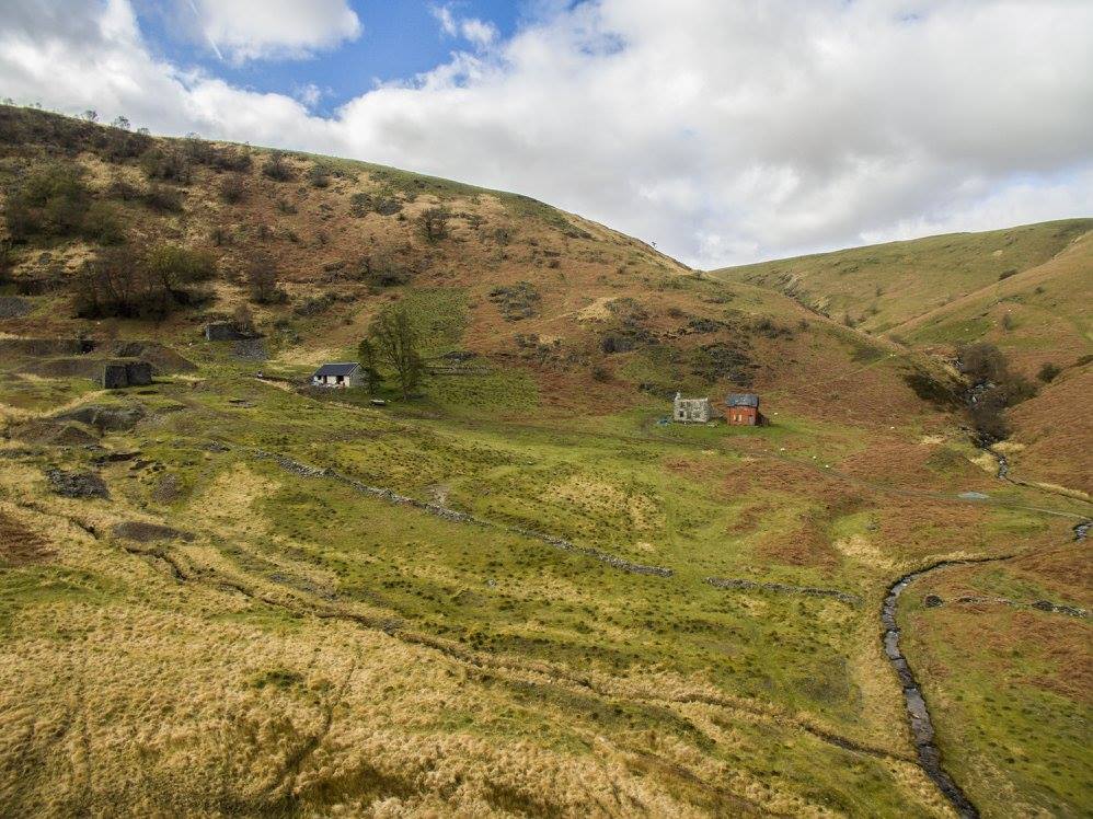
- NANT Y CAR South. Grid ref: SN886609. Dates worked: 18th century. – 1883
Produced copper/lead/zinc.
At Nant y Car south the main shaft, now flooded, was lined with masonry resting on timber lintels. There are also the foundations of a stonework winding arrangement on the western side of the shaft and ‘bob-pit’. The shaft was pumped by a flat-rod system powered by the main wheelpit, the narrow stone-lined culvert to the east of the wheelpit housed these rods.
A tramway connects the shaft structures with the two or three stone built ore bins with picking floors in front. Considerable amounts of ‘jigtailings’ by the bins indicate that there were jiggers in use at the site, probably located on the platform remains on the north-east of the crusher house, which still contains the remains of four beam ends, indicating that there were two crusher rolls in operation. A ramp connects the ore bins to the crusher house. To the east lie two circular ‘buddles’ with stone revetment walls surrounding them. Water would flow from the crusher house via a culvert to the buddle area.
The main leat is largely stone lined and is fed from the Rhiwnant stream. The site has remains of three drainage ‘adits’. A series of three-sided shelters, located amongst some natural stone fall, is presumed to have been used for some form of shelter for people employed to dress the stone for building use.
- DALRHIW. Grid ref: SN885607. Dates worked: 1850 – 1867
Produced copper/lead.
The mine was originally accessed by a footbridge from Nant y Car south mine. The main shaft is located on the southern hill slopes at the top of the site, with a drainage adit on the south bank of the stream. A horse whim would have raised the ore from the shaft. A bob-pit and a wheel pit are associated with the shaft, and the track beds from this system can still be traced. The water channel from the wheel pit runs into Rhiwnant stream.
There are the remains of three ore bins and a small building beside them, probably where the ore was hand sorted before going to the crusher house. The remains of the crusher house and its wheelpit are located down slope from the ore bins. There is a slab floor beside the building which is possibly the washing area. Jigs were powered by another small wheelpit and the stone-slabbed floor on which they stood remains along with jig-waste by the wheelpit wall. No evidence remains of buddles. The mine office/mine managers house has collapsed, attached to it was probably the smithy.
- NANTYGARW. Grid ref: SN874606. Dates worked:1877 – 1899
Produced lead.
Although there a few signs of the earliest workings, most of the remains visible today date from 1886 onwards. The main shaft is stone lined with a timber frame surrounding the top, some timber pump-rods remain in place. Along the south side is the bob-pit and to the east side is a single roomed building of unknown usage. A roughly circular area in the vicinity is probably all that remains of a whim circle. There is a substantial wheelpit to the east with water probably being drawn directly from the stream.
A track leads up to the remains of a processing mill. No wheelpit remains, however, power was presumably provided by water. Three adjoining buildings would once have provided processing machinery. There are also piles of jig waste and the remains of a buddle near to the mill site. Two buildings to the east of the mill consist of stone walls with a concrete cap, which would suggest a timber structure above this point. One of the buildings is divided up internally and may have been a barracks, the other building only contains a single room partition and the presence of a slot in one of the walls suggests the housing of some form of machinery. Jig platforms remain to the east of the shaft.
The remains of a leat exist which probably took ‘slimes’ from the mill to a settling pit. The remains of the mine office are of stone base with a concrete cap, which is divided into two rooms internally. There is also some evidence of a possible garden which appears as a grassy area now. The mine magazine is located at some distance to the east.
- CWM ELAN MINE. Grid ref: SN901651. Dates worked: 1796 – 1877
Produced lead/zinc.
The early workings remain a series of open-cuts, some small tips and the earthwork remains of a few buildings. Other workings from the 18th century are now lost beneath the spoil tips of the larger 19th century operations. The majority of the structural remains at Cwm Elan date from the 1870’s.
The pumping wheelpit for the main shaft would have housed a 36x4ft wheel, water from this wheel would then pass through the archway to be re-used at the crusher wheelpit. Some of the pumping rods and other supporting iron work can still be found around the site.
Ore from the main shaft would be stored in three ore bins, of which only one remains fairly intact. From here the ore would be taken to the crusher house by tramways. The walls of the crusher house still stand almost at full height, and the crushing rolls supporting beams lie close to the building. The associated wheelpit is of similar size to that of the pumping pit, powering a crusher, jiggers and a circular buddle.
Water from the crusher house wheelpit again flowed out of an arch to feed a third smaller wheelpit which powered a buddle below. Water passed along wooden ‘launders’ and the supports remain in situ.
The site shows evidence of three parallel rows of ten settling pits to launder the lead waste, and these all had interconnecting leats. Situated away from the main areas of activity is the magazine, a small roomed stone building used to store explosives.
Glossary of Terms
- Lead: Occurs as a sulphide ore known as galena.
- Ore: Ore is found in veins or ‘lodes’ which run through the country rock sandwiched between layers of quartz or calcite.
- Adits: Drainage levels or tunnels.
- Stoping: The actual removal of the ore.
- Balance bobs/bobpits: The rotating waterwheels powered the pumps and other mechanisms via a system of flat-rods counter balanced by balance bobs in bobpits. (The disadvantage of water power was that in the winter the water supply would freeze and in the summer it would often dry up above ground whilst continuing to enter the mine below ground, leaving the mine unworkable).
- Launder: A wooden trough.
- Tye box: A crude sluice.
- Slime pits: Where any very fine particles could drop out of water suspension for later recovery.
- Jigger: A wire sieve.
- Buddle: A semi-automated dressing machine.
Access and Safety
Although it is possible to access all mines mentioned, they are remote and access is difficult. They are situated away from Rights of Way, and access through fenced land can only be taken where permission from the tenant farmer is sought. The terrain is often uneven and boggy. Mining areas are often dangerous, with open shafts and ground liable to sudden subsidence. Access to the shafts is not allowed and are fenced off for your safety. The piles of waste rock and ruined buildings may be unstable and care must be taken at all times.
Further Reading
The old metal mines of Mid Wales, Part 6. A miscellany. (1991) Bick,D.
CPAT Report No 248 Nantygarw Lead Mine, archaeological ground survey. (1997) Jones,N.W.and Frost, P. The Clwyd-Powys Archaeological Trust.
Lead and lead mining. (1994) Willies,Lynn. Shire Publications Ltd.
Lead mining in Wales. (1967) Lewis,W.J. TheClwydPowys archaeological Trust
CPAT Report No 111.1 Powys metal mines ground survey. (1994). Jones,N.W. and Frost,P.